


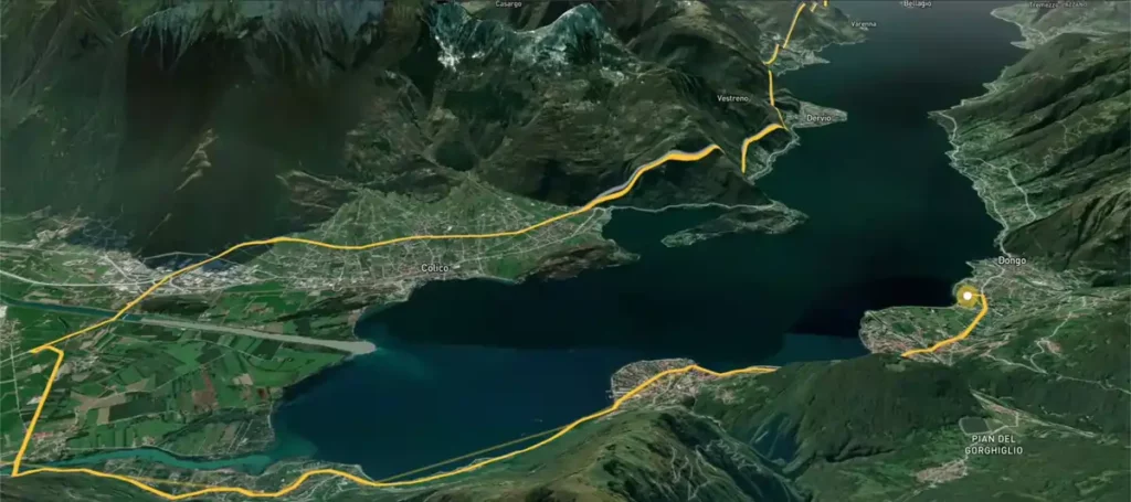
AvoMap is a no-code platform that converts your itineraries (GPS files in GPX or KML format, or manually created tracks) into 3D animated videos.
Tired of static maps that hardly anyone looks at and complex editing?
AvoMap brings your routes to life with AI. Whether it’s hiking, business trips, or sporting events.
The videos are immersive and ready to share on YouTube or Instagram.
All this without heavy software or editing, just an intuitive interface and high-definition renderings in minutes.
Main features of AvoMap
Create custom itineraries

You can import GPX or KML files, or plot your route manually.
It is possible to combine segments on foot, by car, or by air, as well as insert breaks between segments to enrich the visual narrative.
3D HD/4K video animation at 60 fps

AvoMap generates smooth videos at 60 frames per second, in Full HD and 4K (depending on the plan chosen).
The dynamic camera effect automatically follows the route by adjusting the tilt, zoom, and speed for an immersive rendering worthy of a drone flight.
Customizable markers on AvoMap

Add up to 25 points of interest to the route, choosing from over 100 predefined symbols (camps, cities, obstacles).
You can also import your own icons (PNG, SVG) and add a title or description for each marker.
Visual styles, elevation, and fine animation

Choose from 10 map styles, customize colors, thickness, route opacity, or elevation profiles.
You control each segment to adjust the camera, duration, relief presentation, or distances.
Export without subscription and white label
The editor is free to preview, and each exported video consumes one credit.
You can remove the AvoMap logo and add your own custom branding for a professional look.
Instant preview
Once the route is defined, a real-time preview allows you to adjust the speed, angles, and pauses without starting the export.
This prevents wasted credits and speeds up the editing phase.
Pricing for AvoMap
| Options | Basic | Plus | Pro |
|---|---|---|---|
| Monthly fee | $9 | $29 | $79 |
| 4K export | Yes | Yes | Yes |
| Frames per second | 60fps | 60fps | 60fps |
| White label | Yes | Yes | Yes |
| Markers | Unlimited | Unlimited | Unlimited |
| Map styles | 10 | 10 | 10 |
| File import | GPX or KML | GPX or KML | GPX or KML |
Advantages of AvoMap
- Streamlined interface that is easy to use, even without technical knowledge.
- Create 3D HD or 4K videos at 60 fps with dynamic cameras, without having to use complex software.
- Import GPX or KML files, insert an unlimited number of markers, and add your logo for a professional finish.
Disadvantages
- Some users have had to pay extra to market or use the white label.
- Six exports per month can quickly prove limiting.
- The editing level remains basic.
My opinion on AvoMap
AvoMap offers a unique, cinematic visual experience to enhance GPS routes or your manually plotted routes.
The interface is remarkably intuitive.
You can plot, adjust, and then export an immersive 3D video in just a few minutes.
No software or editing required.
The style, pause, and segment blending options (walking, flying, driving) are really cool.
The ability to create Full HD (and soon 4K) videos with a dynamic 60 fps camera, white label, customizable symbols, and various visual styles makes AvoMap particularly suitable for content creators, event organizers, or travel videographers.
However, the options and customization remain limited compared to professional editing tools.
Also, features such as automatic slow motion or keyframe editing are not yet available, but are planned.
AvoMap is a handy solution for turning a trip or race into a visual story without excessive technical effort.